
June 5, 2019
In a 21 page unanimous decision the Indiana State Supreme court upheld two lower court rulings the Town of Brownsburg “did not satisfy its burden of proving it had met the statutory requirements for annexing the disputed territory”. This precedent setting ruling effectively ends the Town’s greater than five year legal battle to involuntarily annex 4500 acres. The court also concluded that it “must consider the evidence submitted by both the municipality and the remonstrators” those who oppose involuntary annexation.
The court only ruled on subsection I.C. 36-4-3-13(a) because the code states if the requirements of 13(b) or (c) must be met to uphold annexation. The court noted that the town did not meet 36-4-3-13(b) so it does not meet 36-4-3-13(a) and the annexation cannot occur. Below is the findings of the court on subsection 13(b).
13(b)(1) The territory sought to be annexed is contiguous to the municipality and one of the following:
(A) the residential population density of the territory sought is at least 3 persons per acre,
(B) 60% of the territory is subdivided, OR
(C) the territory is zoned for commercial, business or industrial uses.
The town agreed that it could not meet the population density or the zoning condition so the question becomes subdivision. By code the term subdivided is not defined and so the court will use the plain , or ordinary and usual sense of the word. The court rejected the town’s plea to let the definition of subdivided up to reasonable judgment call by the town. Instead the court used the definition in the dictionary which defines subdivide as to divide the parts into more parts, or to divide in several parts (i.e. to divide a tract of land). Looking at the statute, the court notes that 60% subdivided must refer to residential zoning and must be referring only to a formal residential subdivision. So the court ruled that subdivision means formally recorded, residential subdivisions, the only permissible unit of measure is acreage and all acreage within the annexation territory must be included in the ratio.
In this part of the case, the court looked at the expert testimony from the town. The expert gave 6 different methods for calculating the percent subdivided of the annexation territory. For each method, he made two calculations one using acreage and one using parcel or tracts. Of the 12 calculations 9 exceeded the 60% threshold.
The remonstrators used a survey by the Indiana Advisory Commission on Intergovernmental Relations showing that 75% of the annexation territory was agricultural. the expert witness noted that only 17% of the territory was subdivided.
The court sided with the trial court and the expert for the remonstrators that approximately 17% of the land was subdivided.
Article Continues Below

The other part of the statute that the court ruled on was 13(c)(1) “needed and can be used by the municipality for its development in the reasonably near future”. The court used the term of four years as the reasonable near future because that is how long the Town must wait before they can try to annex the territory again. The court noted The Ronald Reagan Expressway which was conceived in the 1980’s and does not have clear plans to be extended past its current termination point. The court also noted the I-74 bridge which is targeted for 2026 clearly outside of four years. The court noted that the town did not have plans for a substantial majority of the annexation area and that it would be at least 5 to 15 years until any of the projects would start.
Because the court ruled that the town did not meet the requirements of IC 36-4-3-13(A), they did not need to rule on any other section of the code. This ruling by the Indiana Supreme Court which upholds the lower court decision that Brownsburg cannot annex the north annexation territory means that by statute the town must wait 4 years before pursuing annexation of this territory again.
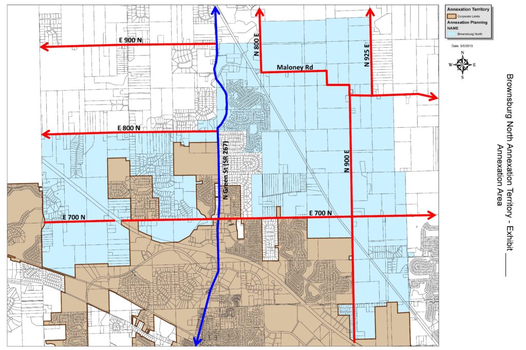
The Brownsburg North Annexation area encompasses nearly 4,500 acres including the Highland Green, Highland Springs, Windridge and Eaker subdivisions. There are 1193 parcels within the boundaries. Approximately 3,000+ people.
To Review the Indiana Supreme Court Judiciary Opinion
19S-PL-342 >> CLICK HERE <<
For a legal analysis of this case
see the article by Dave Stafford of THE INDIANA LAWYER >> CLICK HERE <<
Wish TV Channel 8 Video Interview >> CLICK HERE <<
Link to the Map
of the Brownsburg North Involuntary Annexation Territory >> CLICK HERE <<
The Editor
Updated 2019/06/06 15:30 to include Map of the Involuntary North Annexation

